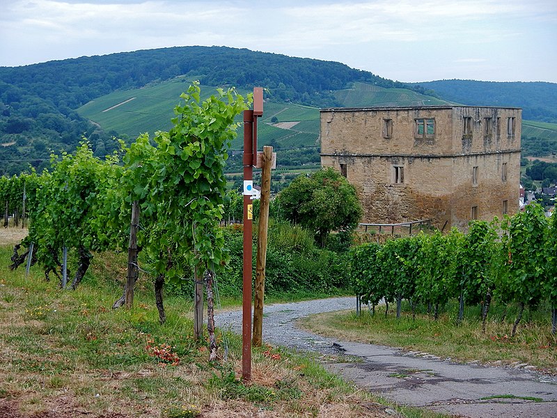
File:Im Oktober 2010 eingeweihter 226 km langer Remstal-Höhenweg, Das Stettener Brotwasser ist eine der besten Riesling-Lagen des Landes. Seine Sandstein-Terrassen liegen romantisch direkt unterhalb der Ruine - panoramio.jpg
From Wikimedia Commons, the free media repository
Jump to navigation
Jump to search

Size of this preview: 800 × 600 pixels. Other resolutions: 320 × 240 pixels | 640 × 480 pixels | 1,024 × 768 pixels | 1,280 × 960 pixels | 2,560 × 1,920 pixels | 4,608 × 3,456 pixels.
Original file (4,608 × 3,456 pixels, file size: 9.07 MB, MIME type: image/jpeg)
File information
Structured data
Captions
Captions
Add a one-line explanation of what this file represents
Summary[edit]
| DescriptionIm Oktober 2010 eingeweihter 226 km langer Remstal-Höhenweg, Das Stettener Brotwasser ist eine der besten Riesling-Lagen des Landes. Seine Sandstein-Terrassen liegen romantisch direkt unterhalb der Ruine - panoramio.jpg | Im Oktober 2010 eingeweihter 226 km langer Remstal-Höhenweg: Das Stettener Brotwasser ist eine der besten Riesling-Lagen des Landes. Seine Sandstein-Terrassen liegen romantisch direkt unterhalb der Ruine Y-Burg. Der ungewöhnliche Lagename rührt von einer im 17. Jahrhundert in Stetten residieren Hofdame her. Diese ersann eine List, um ihren Weinkonsum von der höfischen Öffentlichkeit zu verbergen. Sie ließ sich einfach den Krug, der für das Brotwasser bestimmt war, mit Wein füllen. Und jedes Mal, wenn Sie das trockene Brot in das vermeintliche Wasser tauchte, konnte sie – ohne dass es jemanden auffiel – einen Schluck Wein zu sich nehmen. Die kleine List bleib jedoch nicht sehr lange verborgen und so bekam der Lieblingswein der Hofdame den Namen „Brotwasser“. | ||
| Date | Taken on 19 July 2015 | ||
| Source | https://web.archive.org/web/20161101150014/http://www.panoramio.com/photo/121651581 | ||
| Author | qwesy qwesy | ||
| Permission (Reusing this file) |
This file is licensed under the Creative Commons Attribution 3.0 Unported license. Attribution: qwesy qwesy
|
||
| Panoramio Tags InfoField | Kernen, 2015, Aichwald, Baden-Württemberg, best, Deutschland, Fellbach, Kernen im Remstal, Weinstadt |
| Camera location | 48° 47′ 10.19″ N, 9° 20′ 40.69″ E | View this and other nearby images on: OpenStreetMap |
|---|
File history
Click on a date/time to view the file as it appeared at that time.
| Date/Time | Thumbnail | Dimensions | User | Comment | |
|---|---|---|---|---|---|
| current | 06:45, 23 May 2017 |  | 4,608 × 3,456 (9.07 MB) | Panoramio upload bot (talk | contribs) | == {{int:filedesc}} == {{Information |description=Im Oktober 2010 eingeweihter 226 km langer Remstal-Höhenweg: Das Stettener Brotwasser ist eine der besten Riesling-Lagen des Landes. Seine Sandstein-Terrassen liegen romantisch direkt unterhalb der Rui... |
You cannot overwrite this file.
File usage on Commons
There are no pages that use this file.
Metadata
This file contains additional information such as Exif metadata which may have been added by the digital camera, scanner, or software program used to create or digitize it. If the file has been modified from its original state, some details such as the timestamp may not fully reflect those of the original file. The timestamp is only as accurate as the clock in the camera, and it may be completely wrong.
| Camera manufacturer | NIKON |
|---|---|
| Camera model | COOLPIX AW110 |
| Exposure time | 1/320 sec (0.003125) |
| F-number | f/4.1 |
| ISO speed rating | 125 |
| Date and time of data generation | 12:00, 19 July 2015 |
| Lens focal length | 9.9 mm |
| Latitude | 48° 47′ 10.19″ N |
| Longitude | 9° 20′ 40.69″ E |
| height | 3,456 |
| width | 4,608 |
| Orientation | Normal |
| Horizontal resolution | 300 dpi |
| Vertical resolution | 300 dpi |
| Software used | COOLPIX AW110V1.0 |
| File change date and time | 16:31, 19 July 2015 |
| Y and C positioning | Co-sited |
| Exposure Program | Normal program |
| Exif version | 2.3 |
| Date and time of digitizing | 12:00, 19 July 2015 |
| Meaning of each component |
|
| Image compression mode | 4 |
| APEX exposure bias | 0 |
| Maximum land aperture | 3.9 APEX (f/3.86) |
| Metering mode | Pattern |
| Light source | Unknown |
| Flash | Flash did not fire, compulsory flash suppression |
| Supported Flashpix version | 1 |
| Color space | sRGB |
| File source | Digital still camera |
| Scene type | A directly photographed image |
| Custom image processing | Normal process |
| Exposure mode | Auto exposure |
| White balance | Auto white balance |
| Digital zoom ratio | 0 |
| Focal length in 35 mm film | 55 mm |
| Scene capture type | Standard |
| Scene control | High gain down |
| Contrast | Normal |
| Saturation | Normal |
| Sharpness | Normal |
| Subject distance range | Distant view |
| Unique image ID | 3E634BD1EE1E455EBAD644BDD4FFC757 |
| GPS time (atomic clock) | 10:00 |
| Satellites used for measurement | 09 |
| Geodetic survey data used | WGS-84 |
| GPS date | 19 July 2015 |
| GPS tag version | 2.3.0.0 |
Structured data
Items portrayed in this file
depicts
19 July 2015
48°47'10.187"N, 9°20'40.693"E
0.003125 second
4.1
9.9 millimetre
125
Hidden categories: