Search for Posts, Maps, and Topics
Update: the National Weather Service canceled this particular alert.
Update: the National Weather Service canceled this particular alert.
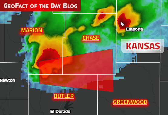
Tornado Warning
KSC015-017-073-115-280230-
/O.NEW.KICT.TO.W.0030.190928T0149Z-190928T0230Z/
BULLETIN - EAS ACTIVATION REQUESTED
Tornado Warning
National Weather Service Wichita KS
849 PM CDT Fri Sep 27 2019
The National Weather Service in Wichita has issued a
* Tornado Warning for...
Southern Chase County in east central Kansas...
Northeastern Butler County in south central Kansas...
Southeastern Marion County in central Kansas...
Northwestern Greenwood County in southeastern Kansas...
* Until 930 PM CDT.
* At 849 PM CDT, a severe thunderstorm capable of producing a tornado
was located near Burns, or 9 miles southeast of Peabody, moving
east at 35 mph.
Update: the National Weather Service canceled this particular alert.
Update: the National Weather Service canceled this particular alert.
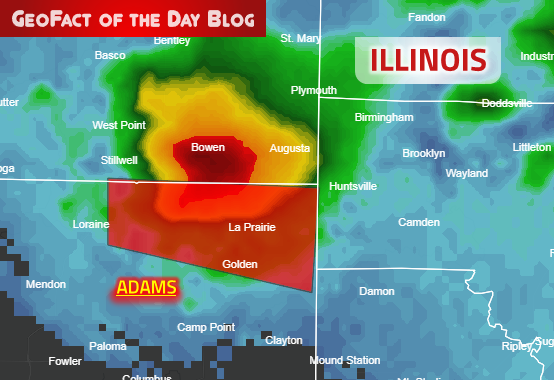
Severe Weather Statement
National Weather Service St Louis MO
831 PM CDT Fri Sep 27 2019
ILC001-280200-
/O.CON.KLSX.TO.W.0048.000000T0000Z-190928T0200Z/
Adams IL-
831 PM CDT Fri Sep 27 2019
...A TORNADO WARNING REMAINS IN EFFECT UNTIL 900 PM CDT FOR
NORTHEASTERN ADAMS COUNTY...
At 831 PM CDT, a severe thunderstorm capable of producing a tornado
was located near Mendon, moving east at 35 mph.
Update: the National Weather Service canceled this particular alert.
Update: the National Weather Service canceled this particular alert.
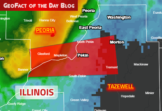
Severe Weather Statement
National Weather Service Lincoln IL
831 PM CDT Fri Sep 27 2019
ILC143-179-280200-
/O.CON.KILX.TO.W.0032.000000T0000Z-190928T0200Z/
Tazewell-Peoria-
831 PM CDT Fri Sep 27 2019
...A TORNADO WARNING REMAINS IN EFFECT UNTIL 900 PM CDT FOR CENTRAL
TAZEWELL AND SOUTHERN PEORIA COUNTIES...
At 831 PM CDT, a severe thunderstorm capable of producing a tornado
was located over Glasford, or 9 miles west of Pekin, moving east at
45 mph.
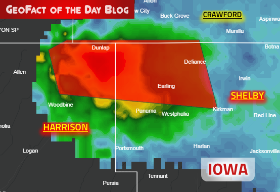
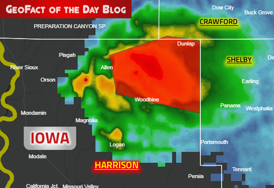
Tornado Warning
IAC085-165-250000-
/O.NEW.KOAX.TO.W.0016.190924T2314Z-190925T0000Z/
BULLETIN - EAS ACTIVATION REQUESTED
Tornado Warning
National Weather Service Omaha/Valley Nebraska
614 PM CDT Tue Sep 24 2019
The National Weather Service in Omaha has issued a
* Tornado Warning for...
Northeastern Harrison County in southwestern Iowa...
Northwestern Shelby County in southwestern Iowa...
* Until 700 PM CDT.
* At 614 PM CDT, a severe thunderstorm capable of producing a tornado
was located near Dunlap, or 20 miles southwest of Denison, moving
east at 20 mph.
HAZARD...Tornado and golf ball size hail.
SOURCE...Radar indicated rotation.
IMPACT...Flying debris will be dangerous to those caught without
shelter. Mobile homes will be damaged or destroyed.
Damage to roofs, windows, and vehicles will occur. Tree
damage is likely.
* This dangerous storm will be near...
Dunlap around 625 PM CDT.
Earling around 655 PM CDT.
Defiance around 700 PM CDT.
Other locations impacted by this tornadic thunderstorm include
Schaben Park, Manteno Recreation Area and Dunlap.
PRECAUTIONARY/PREPAREDNESS ACTIONS...
TAKE COVER NOW! Move to a basement or an interior room on the lowest
floor of a sturdy building. Avoid windows. If you are outdoors, in a
mobile home, or in a vehicle, move to the closest substantial shelter
and protect yourself from flying debris.
&&
LAT...LON 4173 9528 4176 9571 4185 9574 4187 9569
4187 9533
TIME...MOT...LOC 2314Z 264DEG 16KT 4184 9566
TORNADO...RADAR INDICATED
HAIL...1.75IN
$$
Dergan
Severe Weather Statement
National Weather Service Omaha/Valley Nebraska
601 PM CDT Tue Sep 24 2019
IAC085-242315-
/O.CON.KOAX.TO.W.0015.000000T0000Z-190924T2315Z/
Harrison IA-
601 PM CDT Tue Sep 24 2019
...A TORNADO WARNING REMAINS IN EFFECT UNTIL 615 PM CDT FOR
NORTHEASTERN HARRISON COUNTY...
At 559 PM CDT, a confirmed tornado was located 9 miles southwest of
Dunlap, or 25 miles southwest of Denison, moving east at 25 mph.
HAZARD...Damaging tornado and golf ball hail.
SOURCE...Weather spotters confirmed tornado 5 miles southeast of
Pisgah. Two brief touchdowns occurred between 550 PM and
557 PM.
IMPACT...Flying debris will be dangerous to those caught without
shelter. Mobile homes will be damaged or destroyed. Damage
to roofs, windows, and vehicles will occur. Tree damage is
likely.
This tornado will be near...
Dunlap around 615 PM CDT.
Other locations impacted by this tornadic thunderstorm include
Woodbine, Dunlap, Schaben Park and Willow Lake Recreation Area.
PRECAUTIONARY/PREPAREDNESS ACTIONS...
To repeat, a tornado is on the ground. TAKE COVER NOW! Move to a
basement or an interior room on the lowest floor of a sturdy
building. Avoid windows. If you are outdoors, in a mobile home, or in
a vehicle, move to the closest substantial shelter and protect
yourself from flying debris.
&&
LAT...LON 4175 9579 4183 9581 4187 9565 4186 9556
4171 9556
TIME...MOT...LOC 2259Z 262DEG 22KT 4178 9575
TORNADO...OBSERVED
HAIL...1.75IN
$$
Dergan

Tornado Warning
IAC161-242330-
/O.NEW.KDMX.TO.W.0021.190924T2254Z-190924T2330Z/
BULLETIN - EAS ACTIVATION REQUESTED
Tornado Warning
National Weather Service Des Moines IA
554 PM CDT Tue Sep 24 2019
The National Weather Service in Des Moines has issued a
* Tornado Warning for...
Northwestern Sac County in west central Iowa...
* Until 630 PM CDT.
* At 553 PM CDT, a severe thunderstorm capable of producing a tornado
was located over Galva, or 10 miles north of Ida Grove, moving east
at 30 mph.
HAZARD...Tornado and ping pong ball size hail.
SOURCE...Radar indicated rotation.
IMPACT...Flying debris will be dangerous to those caught without
shelter. Mobile homes will be damaged or destroyed.
Damage to roofs, windows, and vehicles will occur. Tree
damage is likely.
* This tornadic thunderstorm will remain over mainly rural areas of
northwestern Sac County, including the following locations...
Nemaha, Early and Schaller.
PRECAUTIONARY/PREPAREDNESS ACTIONS...
This Tornado Warning replaces the Severe Thunderstorm Warning issued
for the same area.
TAKE COVER NOW! Move to a basement or an interior room on the lowest
floor of a sturdy building. Avoid windows. If you are outdoors, in a
mobile home, or in a vehicle, move to the closest substantial shelter
and protect yourself from flying debris.
&&
LAT...LON 4256 9539 4256 9509 4236 9506 4235 9532
4247 9532 4247 9538 4248 9539
TIME...MOT...LOC 2253Z 258DEG 26KT 4248 9541
TORNADO...RADAR INDICATED
HAIL...1.50IN
$$
Beerends
A tornado watch has been issued for parts of Iowa, Minnesota, Nebraska and Wisconsin until 12 AM CDT
Map on NWS Twitter: https://twitter.com/NWStornado/status/1176612903497031681

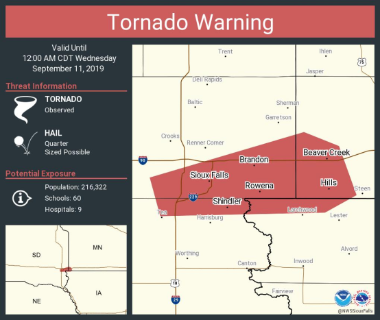
Tornado Warning
IAC093-242300-
/O.NEW.KFSD.TO.W.0039.190924T2229Z-190924T2300Z/
BULLETIN - EAS ACTIVATION REQUESTED
Tornado Warning
National Weather Service Sioux Falls SD
529 PM CDT Tue Sep 24 2019
The National Weather Service in Sioux Falls has issued a
* Tornado Warning for...
Central Ida County in west central Iowa...
* Until 600 PM CDT.
* At 529 PM CDT, a severe thunderstorm capable of producing a tornado
was located near Holstein, or 7 miles northwest of Ida Grove,
moving east at 25 mph.
HAZARD...Tornado and golf ball size hail.
SOURCE...Radar indicated rotation.
IMPACT...Flying debris will be dangerous to those caught without
shelter. Mobile homes will be damaged or destroyed.
Damage to roofs, windows, and vehicles will occur. Tree
damage is likely.
* This dangerous storm will be near...
Holstein around 535 PM CDT.
Ida Grove around 545 PM CDT.
Galva around 550 PM CDT.
PRECAUTIONARY/PREPAREDNESS ACTIONS...
TAKE COVER NOW! Move to a basement or an interior room on the lowest
floor of a sturdy building. Avoid windows. If you are outdoors, in a
mobile home, or in a vehicle, move to the closest substantial shelter
and protect yourself from flying debris.
&&
LAT...LON 4235 9562 4248 9564 4252 9539 4248 9539
4247 9532 4234 9532
TIME...MOT...LOC 2229Z 267DEG 22KT 4242 9559
TORNADO...RADAR INDICATED
HAIL...1.75IN
$$
JM
Update: the National Weather Service canceled this particular alert.

Update: the National Weather Service canceled this particular alert.
Tornado Warning
KSC049-205-220015-
/O.NEW.KICT.TO.W.0029.190921T2326Z-190922T0015Z/
BULLETIN - EAS ACTIVATION REQUESTED
Tornado Warning
National Weather Service Wichita KS
626 PM CDT Sat Sep 21 2019
The National Weather Service in Wichita has issued a
* Tornado Warning for...
Southeastern Elk County in southeastern Kansas...
Western Wilson County in southeastern Kansas...
* Until 715 PM CDT.
* At 625 PM CDT, a severe thunderstorm capable of producing a tornado
was located near Longton, or 13 miles southwest of Fredonia, moving
east at 20 mph.
The new Republic of BENIN map on GeoFact of the Day provides accurate placements of towns, cities, and country borders. Feel free to comment on what you think about my map, and feel free to share your suggestions in regards to future maps! Access the Benin post (↗) to enjoy the newest addition to GeoFact of the Day's cartographic collection!
Update: the National Weather Service canceled this particular alert.

Update: the National Weather Service canceled this particular alert.
Tornado Warning
MIC045-120100-
/O.NEW.KGRR.TO.W.0005.190912T0030Z-190912T0100Z/
BULLETIN - EAS ACTIVATION REQUESTED
Tornado Warning
National Weather Service Grand Rapids MI
830 PM EDT Wed Sep 11 2019
The National Weather Service in Grand Rapids has issued a
* Tornado Warning for...
Northern Eaton County in south central Michigan...
* Until 900 PM EDT.
* At 830 PM EDT, a tornado producing storm was located near Lake
Odessa, or 11 miles southeast of Lowell, moving southeast at 45
mph.
HAZARD...Damaging tornado.
SOURCE...Radar confirmed tornado.
Update: the National Weather Service canceled this particular alert.

Update: the National Weather Service canceled this particular alert.
Tornado Warning
MIC067-081-120030-
/O.NEW.KGRR.TO.W.0004.190911T2358Z-190912T0030Z/
BULLETIN - EAS ACTIVATION REQUESTED
Tornado Warning
National Weather Service Grand Rapids MI
758 PM EDT Wed Sep 11 2019
The National Weather Service in Grand Rapids has issued a
* Tornado Warning for...
Southeastern Kent County in southwestern Michigan...
Central Ionia County in south central Michigan...
* Until 830 PM EDT.
* At 757 PM EDT, a tornado producing storm was located near Forest
Hills, or 6 miles northwest of Lowell, moving east at 40 mph.
Multiple brief tornadoes are occuring with this storm!
HAZARD...Damaging tornado.
SOURCE...Radar confirmed tornado.
Update: the National Weather Service canceled this particular alert.

Update: the National Weather Service canceled this particular alert.
Tornado Warning
ILC031-097-111-120045-
/O.NEW.KLOT.TO.W.0015.190911T2353Z-190912T0045Z/
BULLETIN - EAS ACTIVATION REQUESTED
Tornado Warning
National Weather Service Chicago/Romeoville
653 PM CDT Wed Sep 11 2019
The National Weather Service in Chicago has issued a
* Tornado Warning for...
Lake County in northeastern Illinois...
Southeastern McHenry County in northeastern Illinois...
North central Cook County in northeastern Illinois...
* Until 745 PM CDT.
* At 653 PM CDT, a severe thunderstorm capable of producing a tornado
was located over Wauconda, moving east at 30 mph.
Update: the National Weather Service canceled this particular alert.

Update: the National Weather Service canceled this particular alert.
Tornado Warning
NEC075-091-120030-
/O.NEW.KLBF.TO.W.0015.190911T2353Z-190912T0030Z/
BULLETIN - EAS ACTIVATION REQUESTED
Tornado Warning
National Weather Service North Platte NE
553 PM MDT Wed Sep 11 2019
The National Weather Service in North Platte has issued a
* Tornado Warning for...
Grant County in west central Nebraska...
Southwestern Hooker County in west central Nebraska...
* Until 630 PM MDT.
* At 552 PM MDT, a severe thunderstorm capable of producing a tornado
was located 12 miles southwest of Hyannis, or 20 miles northwest of
Arthur, moving northeast at 40 mph.
Update: the National Weather Service canceled this particular alert.

Update: the National Weather Service canceled this particular alert.
Tornado Warning
NEC031-120030-
/O.NEW.KLBF.TO.W.0014.190911T2338Z-190912T0030Z/
BULLETIN - EAS ACTIVATION REQUESTED
Tornado Warning
National Weather Service North Platte NE
538 PM MDT Wed Sep 11 2019
The National Weather Service in North Platte has issued a
* Tornado Warning for...
Southwestern Cherry County in north central Nebraska...
* Until 630 PM MDT.
* At 538 PM MDT, a severe thunderstorm capable of producing a tornado
was located 18 miles north of Ashby, or 41 miles southeast of
Gordon, moving northeast at 20 mph.
Update: the National Weather Service canceled this particular alert.

Update: the National Weather Service canceled this particular alert.
Severe Weather Statement
National Weather Service Grand Rapids MI
518 PM EDT Wed Sep 11 2019
MIC107-123-112130-
/O.CON.KGRR.TO.W.0003.000000T0000Z-190911T2130Z/
Newaygo MI-Mecosta MI-
518 PM EDT Wed Sep 11 2019
...A TORNADO WARNING REMAINS IN EFFECT UNTIL 530 PM EDT FOR EAST
CENTRAL NEWAYGO AND NORTHWESTERN MECOSTA COUNTIES...
At 516 PM EDT, a severe thunderstorm capable of producing a tornado
was located 6 miles southwest of Big Rapids, moving east at 25 mph.
Update: the National Weather Service canceled this particular alert.

Update: the National Weather Service canceled this particular alert.
Tornado Warning
MNC133-SDC099-110530-
/O.NEW.KFSD.TO.W.0038.190911T0454Z-190911T0530Z/
BULLETIN - EAS ACTIVATION REQUESTED
Tornado Warning
National Weather Service Sioux Falls SD
1200 AM CDT Wed Sep 11 2019
The National Weather Service in Sioux Falls has issued a
* Tornado Warning for...
West central Rock County in southwestern Minnesota...
East central Minnehaha County in southeastern South Dakota...
* Until 1230 AM CDT.
* At 1154 PM CDT, a severe thunderstorm capable of producing a
tornado was located over Palisades State Park, or 14 miles
northeast of Sioux Falls, moving north at 15 mph.
Update: the National Weather Service canceled this particular alert.
Update: the National Weather Service canceled this particular alert.
Tornado Warning
IAC119-MNC133-SDC083-099-110500-
/O.NEW.KFSD.TO.W.0037.190911T0427Z-190911T0500Z/
BULLETIN - EAS ACTIVATION REQUESTED
Tornado Warning
National Weather Service Sioux Falls SD
1127 PM CDT Tue Sep 10 2019
The National Weather Service in Sioux Falls has issued a
* Tornado Warning for...
Northwestern Lyon County in northwestern Iowa...
Southwestern Rock County in southwestern Minnesota...
Southeastern Minnehaha County in southeastern South Dakota...
North central Lincoln County in southeastern South Dakota...
* Until midnight CDT.
* At 1127 PM CDT, a severe thunderstorm capable of producing a
tornado was located over Sioux Falls, moving east at 40 mph.
Update: the National Weather Service canceled this particular alert.

Update: the National Weather Service canceled this particular alert.
Tornado Warning
SDC083-125-110430-
/O.NEW.KFSD.TO.W.0036.190911T0404Z-190911T0430Z/
BULLETIN - EAS ACTIVATION REQUESTED
Tornado Warning
National Weather Service Sioux Falls SD
1104 PM CDT Tue Sep 10 2019
The National Weather Service in Sioux Falls has issued a
* Tornado Warning for...
Northern Lincoln County in southeastern South Dakota...
Northeastern Turner County in southeastern South Dakota...
* Until 1130 PM CDT.
* At 1103 PM CDT, a severe thunderstorm capable of producing a
tornado was located over Chancellor, or near Parker, moving east at
45 mph.
Update: the National Weather Service canceled this particular alert.

Update: the National Weather Service canceled this particular alert.
Tornado Warning
SDC087-099-125-110430-
/O.NEW.KFSD.TO.W.0035.190911T0353Z-190911T0430Z/
BULLETIN - EAS ACTIVATION REQUESTED
Tornado Warning
National Weather Service Sioux Falls SD
1053 PM CDT Tue Sep 10 2019
The National Weather Service in Sioux Falls has issued a
* Tornado Warning for...
Eastern Hutchinson County in southeastern South Dakota...
Southwestern Minnehaha County in southeastern South Dakota...
Southeastern McCook County in southeastern South Dakota...
North central Turner County in southeastern South Dakota...
* Until 1130 PM CDT.
* At 1053 PM CDT, a severe thunderstorm capable of producing a
tornado was located near Canistota, or 7 miles southwest of Lake
Vermillion State Recreation Area, moving east at 30 mph.
Update: the National Weather Service canceled this particular alert.

Update: the National Weather Service canceled this particular alert.
Tornado Warning
SDC061-067-087-110330-
/O.NEW.KFSD.TO.W.0033.190911T0256Z-190911T0330Z/
BULLETIN - EAS ACTIVATION REQUESTED
Tornado Warning
National Weather Service Sioux Falls SD
956 PM CDT Tue Sep 10 2019
The National Weather Service in Sioux Falls has issued a
* Tornado Warning for...
Southwestern McCook County in southeastern South Dakota...
Southeastern Hanson County in southeastern South Dakota...
North central Hutchinson County in southeastern South Dakota...
* Until 1030 PM CDT.
* At 956 PM CDT, a severe thunderstorm capable of producing a tornado
was located over Clayton, or 15 miles east of Parkston, moving
northeast at 25 mph.
Update: the National Weather Service canceled this particular alert.

Update: the National Weather Service canceled this particular alert.
Severe Weather Statement
National Weather Service Sioux Falls SD
904 PM CDT Tue Sep 10 2019
SDC067-110230-
/O.CON.KFSD.TO.W.0031.000000T0000Z-190911T0230Z/
Hutchinson SD-
904 PM CDT Tue Sep 10 2019
...A TORNADO WARNING REMAINS IN EFFECT UNTIL 930 PM CDT FOR WESTERN
HUTCHINSON COUNTY...
At 904 PM CDT, a severe thunderstorm capable of producing a tornado
was located just east of Tripp, or 12 miles south of Parkston,
moving northeast at 20 mph.
Update: the National Weather Service canceled this particular alert.

Update: the National Weather Service canceled this particular alert.
Severe Weather Statement
National Weather Service Sioux Falls SD
903 PM CDT Tue Sep 10 2019
SDC003-035-110215-
/O.CON.KFSD.TO.W.0030.000000T0000Z-190911T0215Z/
Davison SD-Aurora SD-
903 PM CDT Tue Sep 10 2019
...A TORNADO WARNING REMAINS IN EFFECT UNTIL 915 PM CDT FOR
SOUTHWESTERN DAVISON AND EAST CENTRAL AURORA COUNTIES...
At 902 PM CDT, a severe thunderstorm capable of producing a tornado
was located near Stickney, or 11 miles southeast of Plankinton,
moving east at 25 mph.
Update: the National Weather Service canceled this particular alert.

Update: the National Weather Service canceled this particular alert.
Tornado Warning
SDC009-023-110145-
/O.NEW.KFSD.TO.W.0029.190911T0107Z-190911T0145Z/
BULLETIN - EAS ACTIVATION REQUESTED
Tornado Warning
National Weather Service Sioux Falls SD
807 PM CDT Tue Sep 10 2019
The National Weather Service in Sioux Falls has issued a
* Tornado Warning for...
Southeastern Charles Mix County in south central South Dakota...
Western Bon Homme County in southeastern South Dakota...
* Until 845 PM CDT.
* At 806 PM CDT, a severe thunderstorm capable of producing a tornado
was located 8 miles southwest of Avon, or 16 miles west of Tyndall,
moving north at 20 mph.
Update: the National Weather Service canceled this particular alert.

Update: the National Weather Service canceled this particular alert.
Tornado Warning
SDC023-043-110130-
/O.NEW.KFSD.TO.W.0028.190911T0058Z-190911T0130Z/
BULLETIN - EAS ACTIVATION REQUESTED
Tornado Warning
National Weather Service Sioux Falls SD
758 PM CDT Tue Sep 10 2019
The National Weather Service in Sioux Falls has issued a
* Tornado Warning for...
North central Charles Mix County in south central South Dakota...
Northwestern Douglas County in south central South Dakota...
* Until 830 PM CDT.
* At 758 PM CDT, a severe thunderstorm capable of producing a tornado
was located near Platte, or 18 miles northwest of Lake Andes,
moving east at 20 mph.
Update: the National Weather Service canceled this particular alert.

Update: the National Weather Service canceled this particular alert.
Tornado Warning
MIC151-110145-
/O.NEW.KDTX.TO.W.0011.190911T0052Z-190911T0145Z/
BULLETIN - EAS ACTIVATION REQUESTED
Tornado Warning
National Weather Service Detroit/Pontiac MI
852 PM EDT Tue Sep 10 2019
The National Weather Service in Detroit/Pontiac has issued a
* Tornado Warning for...
Central Sanilac County in southeastern Michigan...
* Until 945 PM EDT.
* At 852 PM EDT, a severe thunderstorm capable of producing a tornado
was located near Kingston, or near Marlette, moving east at 35 mph.
Update: the National Weather Service canceled this particular alert.

Update: the National Weather Service canceled this particular alert.
Tornado Warning
MIC157-110100-
/O.NEW.KDTX.TO.W.0010.190911T0036Z-190911T0100Z/
BULLETIN - EAS ACTIVATION REQUESTED
Tornado Warning
National Weather Service Detroit/Pontiac MI
836 PM EDT Tue Sep 10 2019
The National Weather Service in Detroit/Pontiac has issued a
* Tornado Warning for...
East central Tuscola County in southeastern Michigan...
* Until 900 PM EDT.
* At 835 PM EDT, a severe thunderstorm capable of producing a tornado
was located near Caro, moving east at 35 mph.
Update: the National Weather Service canceled this particular alert.
Update: the National Weather Service canceled this particular alert.
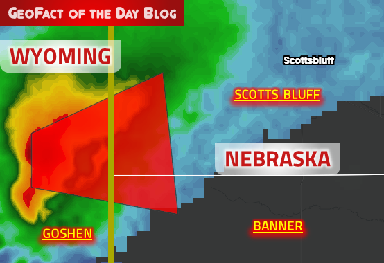
Tornado Warning
NEC007-157-WYC015-110030-
/O.NEW.KCYS.TO.W.0037.190910T2359Z-190911T0030Z/
BULLETIN - EAS ACTIVATION REQUESTED
Tornado Warning
National Weather Service Cheyenne WY
559 PM MDT Tue Sep 10 2019
The National Weather Service in Cheyenne has issued a
* Tornado Warning for...
Southwestern Scotts Bluff County in the Panhandle of Nebraska...
Northwestern Banner County in the Panhandle of Nebraska...
Southeastern Goshen County in southeastern Wyoming...
* Until 630 PM MDT.
* At 559 PM MDT, a severe thunderstorm capable of producing a tornado
was located over Hawk Springs Campground, or 23 miles south of
Torrington, moving east at 25 mph.
Update: the National Weather Service canceled this particular alert.
Update: the National Weather Service canceled this particular alert.
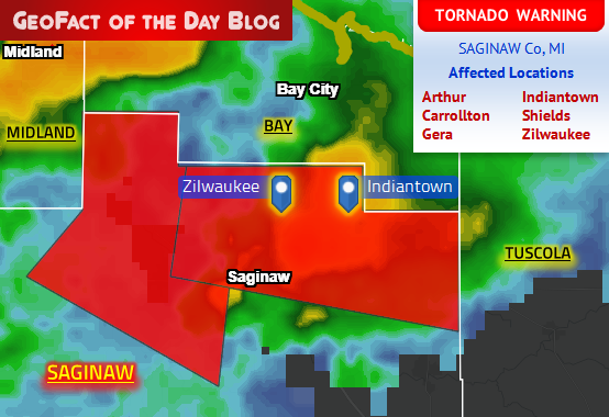
Tornado Warning
MIC145-110000-
/O.NEW.KDTX.TO.W.0009.190910T2336Z-190911T0000Z/
BULLETIN - EAS ACTIVATION REQUESTED
Tornado Warning
National Weather Service Detroit/Pontiac MI
736 PM EDT Tue Sep 10 2019
The National Weather Service in Detroit/Pontiac has issued a
* Tornado Warning for...
Northeastern Saginaw County in southeastern Michigan...
* Until 800 PM EDT.
* At 735 PM EDT, a severe thunderstorm capable of producing a tornado
was located over Zilwaukee, or near Saginaw, moving east at 35 mph.
Update: the National Weather Service canceled this particular alert.

Update: the National Weather Service canceled this particular alert.
Tornado Warning
MIC145-102345-
/O.NEW.KDTX.TO.W.0008.190910T2300Z-190910T2345Z/
BULLETIN - EAS ACTIVATION REQUESTED
Tornado Warning
National Weather Service Detroit/Pontiac MI
700 PM EDT Tue Sep 10 2019
The National Weather Service in Detroit/Pontiac has issued a
* Tornado Warning for...
Northwestern Saginaw County in southeastern Michigan...
* Until 745 PM EDT.
* At 659 PM EDT, a severe thunderstorm capable of producing a tornado
was located near Merrill, or 13 miles southwest of Midland, moving
east at 35 mph.
Update: the National Weather Service canceled this particular alert.

Update: the National Weather Service canceled this particular alert.
Tornado Warning
MIC111-102330-
/O.NEW.KDTX.TO.W.0007.190910T2242Z-190910T2330Z/
BULLETIN - EAS ACTIVATION REQUESTED
Tornado Warning
National Weather Service Detroit/Pontiac MI
642 PM EDT Tue Sep 10 2019
The National Weather Service in Detroit/Pontiac has issued a
* Tornado Warning for...
Southern Midland County in southeastern Michigan...
* Until 730 PM EDT.
* At 642 PM EDT, a severe thunderstorm capable of producing a tornado
was located over Pleasant Valley, or 8 miles northeast of Alma,
moving east at 40 mph.
Update: the National Weather Service canceled this particular alert.

Update: the National Weather Service canceled this particular alert.
Tornado Warning
NEC165-WYC015-102315-
/O.NEW.KCYS.TO.W.0034.190910T2236Z-190910T2315Z/
BULLETIN - EAS ACTIVATION REQUESTED
Tornado Warning
National Weather Service Cheyenne WY
436 PM MDT Tue Sep 10 2019
The National Weather Service in Cheyenne has issued a
* Tornado Warning for...
Southwestern Sioux County in the Panhandle of Nebraska...
Northeastern Goshen County in southeastern Wyoming...
* Until 515 PM MDT.
* At 435 PM MDT, a severe thunderstorm capable of producing a tornado
was located 12 miles southeast of Jay Em, or 17 miles north of
Torrington, moving southeast at 15 mph.
Update: the National Weather Service canceled this particular alert.

Update: the National Weather Service canceled this particular alert.
Tornado Warning
WYC015-102245-
/O.NEW.KCYS.TO.W.0033.190910T2217Z-190910T2245Z/
BULLETIN - EAS ACTIVATION REQUESTED
Tornado Warning
National Weather Service Cheyenne WY
417 PM MDT Tue Sep 10 2019
The National Weather Service in Cheyenne has issued a
* Tornado Warning for...
Northeastern Goshen County in southeastern Wyoming...
* Until 445 PM MDT.
* At 417 PM MDT, a severe thunderstorm capable of producing a tornado
was located 8 miles south of Jay Em, or 22 miles northwest of
Torrington, moving east at 10 mph.
HAZARD...Tornado and ping pong ball size hail.
SOURCE...Weather spotters reported funnel cloud.
Update: the National Weather Service canceled this particular alert.

Update: the National Weather Service canceled this particular alert.
Severe Weather Statement
National Weather Service Cheyenne WY
315 PM MDT Tue Sep 10 2019
WYC015-031-102145-
/O.CON.KCYS.TO.W.0031.000000T0000Z-190910T2145Z/
Goshen WY-Platte WY-
315 PM MDT Tue Sep 10 2019
...A TORNADO WARNING REMAINS IN EFFECT UNTIL 345 PM MDT FOR
NORTHWESTERN GOSHEN AND NORTHEASTERN PLATTE COUNTIES...
At 314 PM MDT, a confirmed tornado was located 8 miles east of
Guernsey Campground, or 26 miles northeast of Wheatland, moving east
at 25 mph.
HAZARD...Damaging tornado and golf ball size hail.
SOURCE...Emergency management confirmed tornado.
Update: the National Weather Service canceled this particular alert.
Update: the National Weather Service canceled this particular alert.
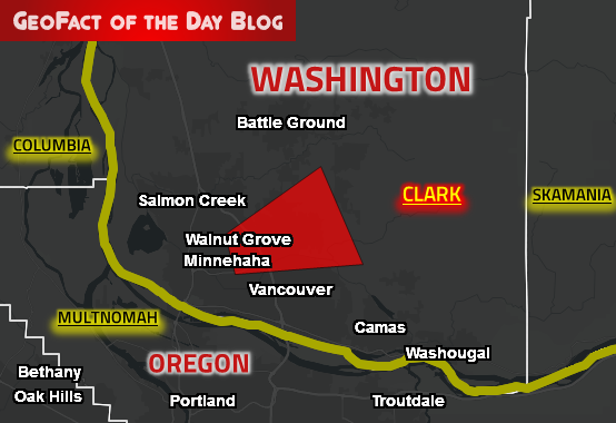
Tornado Warning
WAC011-090315-
/O.NEW.KPQR.TO.W.0002.190909T0248Z-190909T0315Z/
BULLETIN - EAS ACTIVATION REQUESTED
Tornado Warning
National Weather Service Portland OR
748 PM PDT Sun Sep 8 2019
The National Weather Service in Portland has issued a
* Tornado Warning for...
South central Clark County in southwestern Washington...
* Until 815 PM PDT..
* At 747 PM PDT, a confirmed tornado was located over Orchards, or
near Vancouver Downtown, moving east at 15 mph.
HAZARD...Damaging tornado.
SOURCE...Weather spotters confirmed tornado.
Update: the National Weather Service canceled this particular alert.

Update: the National Weather Service canceled this particular alert.
Tornado Warning
ORC051-090200-
/O.NEW.KPQR.TO.W.0001.190909T0146Z-190909T0200Z/
BULLETIN - EAS ACTIVATION REQUESTED
Tornado Warning
National Weather Service Portland OR
646 PM PDT Sun Sep 8 2019
The National Weather Service in Portland has issued a
* Tornado Warning for...
Western Multnomah County in northwestern Oregon...
* Until 700 PM PDT..
* At 645 PM PDT, a severe thunderstorm capable of producing a
tornado was located 5 miles north of Rockcreek, moving east at 15
mph.
HAZARD...Tornado.
SOURCE...Weather spotters reported funnel cloud.
 season 31, broadcasted on CBS in 2019")
● Arriving in Dubai and driving to a desert bonfire, which was hosted by Emiratis who owned luxurious sportscars. Teams enjoyed tea and date fruit then found a clue inside a sportscar.
● Riding an elevator to the top of the iconic Dubai Frame landmark to receive their Detour clue.
● Detour, choice between "Fall" or "Find": playing the Mission 828 virtual-reality simulation in the world's tallest building (Burj Khalifa) and recalling the answers to several questions about that game or finding a blue, green, red, purple, and white lighted egg in Dubai Garden Glow's Dinosaur Park while wearing T-Rex costumes.
● Roadblock: attending a silent disco party and finding a headphone-wearing attendee who is dancing to the same song that the party's DJ is listening to.
● Riding the world's longest urban zipline from the top of a building down toward episode 5's Pit Stop.
● Pit Stop: Dubai Marina
Season 31, Episode 5
First and Last Places at the Pit Stop
1st — Becca Droz & Floyd Pierce
1st place prize — $5,000 each
Last — Elissa Slater & Rachel Reilly-Villegas
Eliminated from the competition? No (non-elimination episode)
● Sliding on a sled down a slope in the snowy, indoor SnowTown Saigon facility and receiving their next clue from a someone dressed as a polar bear.
● Roadblock: passing a moped driving test on a complicated, twisty course by staying between the yellow lines.
● Detour, choice between "Irritation" or "Irrigation": paddling a basket boat while encountering fishermen obstacles to pick up and return a basket of fish or building a waterwheel out of bamboo then filling a jug with the waterwheel's water. Both detour options were hosted at the serene Bình Quới village.
● Pit Stop: Tầm Vu Park, adjacent to the Thanh Đa Canal in Ho Chi Minh City
Season 31, Episode 4
First and Last Places at the Pit Stop
1st — Christie Woods & Colin Guinn
1st place prize — Trip to the DOMINICAN REPUBLIC*
Last — Corinne Kaplan & Eliza Orlins
Eliminated from the competition? Yes
* A destination which I would NOT recommend at this time due to way too many reports of suspicious tourist deaths (particularly at several resorts)! If Christie and Colin already took their vacation to the Dominican Republic, they seem to be doing okay.
 In episode 3 of the U.S. version of The Amazing Race on CBS, teams hopped one country over from Luang Phabang (Luang Prabang) along the Mekong River in northern LAOS to Ho Chi Minh City, a city of over 8 million people in southern VIETNAM. Sorted by chronological order, here were the challenges and happenings encountered by teams in this episode:
● Finding a doctor at the House of Vietnamese Medicine to receive herbal remedies and their next clue.
● Detour, choice between "Reel It In" or "Light It Up": fishing for eight prawns in a restaurant's indoor pool or dancing in sync with the 218 Dance Group while wearing colorfully lit outfits.
● Roadblock: learning the lyrics of a Vietnamese song and singing it karaoke-style in front of a crowd at Kingdom Karaoke.
● Pit Stop: Hồ Thị Kỷ Flower Market in Ho Chi Minh City
Season 31, Episode 3
First and Last Places at the Pit Stop
1st — Becca Droz & Floyd Pierce
1st place prize — Trip to the THE BAHAMAS
Last — Bret LaBelle & Chris Hammons
Eliminated from the competition? No (non-elimination episode)

Update: the National Weather Service canceled this particular alert.

Update: the National Weather Service canceled this particular alert.
Tornado Warning
NCC129-141-051045-
/O.NEW.KILM.TO.W.0027.190905T1007Z-190905T1045Z/
BULLETIN - EAS ACTIVATION REQUESTED
Tornado Warning
National Weather Service Wilmington NC
607 AM EDT Thu Sep 5 2019
The National Weather Service in Wilmington has issued a
* Tornado Warning for...
New Hanover County in southeastern North Carolina...
Southwestern Pender County in southeastern North Carolina...
* Until 645 AM EDT.
* At 606 AM EDT, severe thunderstorms capable of producing a tornado
were located along a line extending from 9 miles southeast of
Johnny Mercer Pier to near North Masonboro Island, moving northwest
at 35 mph.
Update: the National Weather Service canceled this particular alert.

Update: the National Weather Service canceled this particular alert.
Tornado Warning
SCC041-043-051-067-089-051045-
/O.NEW.KILM.TO.W.0025.190905T0958Z-190905T1045Z/
BULLETIN - EAS ACTIVATION REQUESTED
Tornado Warning
National Weather Service Wilmington NC
558 AM EDT Thu Sep 5 2019
The National Weather Service in Wilmington has issued a
* Tornado Warning for...
Southeastern Florence County in northeastern South Carolina...
Northeastern Georgetown County in northeastern South Carolina...
Southwestern Horry County in northeastern South Carolina...
South central Marion County in northeastern South Carolina...
Northeastern Williamsburg County in northeastern South Carolina...
* Until 645 AM EDT.
* At 558 AM EDT, a severe thunderstorm capable of producing a tornado
was located over Bucksville, or near Red Hill, moving west at 30
mph.
Update: the National Weather Service canceled this particular alert.

Update: the National Weather Service canceled this particular alert.
Tornado Warning
NCC019-047-051030-
/O.NEW.KILM.TO.W.0023.190905T0938Z-190905T1030Z/
BULLETIN - EAS ACTIVATION REQUESTED
Tornado Warning
National Weather Service Wilmington NC
538 AM EDT Thu Sep 5 2019
The National Weather Service in Wilmington has issued a
* Tornado Warning for...
West central Brunswick County in southeastern North Carolina...
Central Columbus County in southeastern North Carolina...
* Until 630 AM EDT.
* At 538 AM EDT, a tornado producing storm was located over Makatoka,
or 9 miles north of Shallotte, moving west at 35 mph.
HAZARD...Damaging tornado.
SOURCE...Radar confirmed tornado.
Update: the National Weather Service canceled this particular alert.

Update: the National Weather Service canceled this particular alert.
Tornado Warning
NCC019-050915-
/O.NEW.KILM.TO.W.0014.190905T0838Z-190905T0915Z/
BULLETIN - EAS ACTIVATION REQUESTED
Tornado Warning
National Weather Service Wilmington NC
438 AM EDT Thu Sep 5 2019
The National Weather Service in Wilmington has issued a
* Tornado Warning for...
South central Brunswick County in southeastern North Carolina...
* Until 515 AM EDT.
* At 437 AM EDT, a severe thunderstorm capable of producing a tornado
was located over Bald Head Island, moving northwest at 35 mph.
Update: the National Weather Service canceled this particular alert.
Update: the National Weather Service canceled this particular alert.
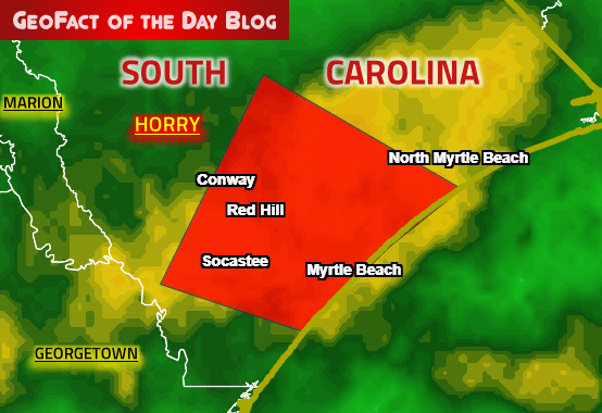
Tornado Warning
SCC051-050830-
/O.NEW.KILM.TO.W.0011.190905T0801Z-190905T0830Z/
BULLETIN - EAS ACTIVATION REQUESTED
Tornado Warning
National Weather Service Wilmington NC
401 AM EDT Thu Sep 5 2019
The National Weather Service in Wilmington has issued a
* Tornado Warning for...
South central Horry County in northeastern South Carolina...
* Until 430 AM EDT.
* At 400 AM EDT, a confirmed waterspout was located just offshore
near Myrtle Beach, moving west at 40 mph.
HAZARD...Tornado.
SOURCE...Doppler Radar indicated.
Update: the National Weather Service canceled this particular alert.
Update: the National Weather Service canceled this particular alert.
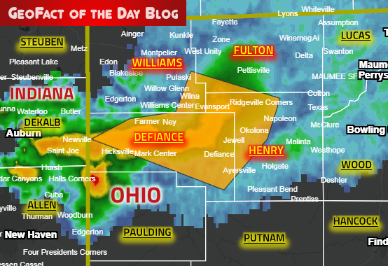
Severe Thunderstorm Warning
OHC039-051-069-171-040500-
/O.NEW.KIWX.SV.W.0152.190904T0427Z-190904T0500Z/
BULLETIN - IMMEDIATE BROADCAST REQUESTED
Severe Thunderstorm Warning
National Weather Service Northern Indiana
1227 AM EDT Wed Sep 4 2019
The National Weather Service in Northern Indiana has issued a
* Severe Thunderstorm Warning for...
Defiance County in northwestern Ohio...
Western Henry County in northwestern Ohio...
Southwestern Fulton County in northwestern Ohio...
Southern Williams County in northwestern Ohio...
* Until 100 AM EDT.
* At 1227 AM EDT, severe thunderstorms were located along a line
extending from Holiday City to near Bryan to near Hicksville,
moving east at 50 mph.
Update: the National Weather Service canceled this particular alert.

Update: the National Weather Service canceled this particular alert.
Severe Thunderstorm Warning
INC033-151-OHC171-040445-
/O.NEW.KIWX.SV.W.0151.190904T0409Z-190904T0445Z/
BULLETIN - IMMEDIATE BROADCAST REQUESTED
Severe Thunderstorm Warning
National Weather Service Northern Indiana
1209 AM EDT Wed Sep 4 2019
The National Weather Service in Northern Indiana has issued a
* Severe Thunderstorm Warning for...
Eastern Steuben County in northeastern Indiana...
Northeastern De Kalb County in northeastern Indiana...
Western Williams County in northwestern Ohio...
* Until 1245 AM EDT.
* At 1208 AM EDT, severe thunderstorms were located along a line
extending from near Fremont to Waterloo, moving east at 35 mph.
Update: the National Weather Service canceled this particular alert.
Update: the National Weather Service canceled this particular alert.
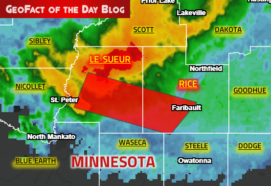
Tornado Warning
MNC079-131-030415-
/O.NEW.KMPX.TO.W.0050.190903T0344Z-190903T0415Z/
BULLETIN - EAS ACTIVATION REQUESTED
Tornado Warning
National Weather Service Twin Cities/Chanhassen MN
1044 PM CDT Mon Sep 2 2019
The National Weather Service in The Twin Cities has issued a
* Tornado Warning for...
Southeastern Le Sueur County in south central Minnesota...
Southwestern Rice County in south central Minnesota...
* Until 1115 PM CDT.
* At 1044 PM CDT, a severe thunderstorm capable of producing a
tornado was located over Le Center, or 19 miles northeast of
Mankato, moving east at 55 mph.
Blog Content
● Content and graphics are created by me (pseudonym: Wonderful World), except when I credit other sources.
● I do not copy and paste from other websites. Therefore, all posts are original but may sometimes include information, links, and/or images from credited external sources. To use a GeoFact of the Day Blog image for your website or project, write a comment below a post — then I may approve your request.
● Feel free to offer comments, suggestions, and compliments on any post or page! You can be anonymous. Spam comments with non-relevant links will be deleted.
● Thanks for your loyal readership on the educational and reliable GeoFact of the Day Blog, in existence since 2008!


