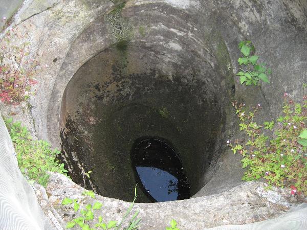
Gletschertopf
In der Nähe von Weiler im Allgäu befindet sich ein kleines geologisches Naturphänomen. Eine Tafel weist auf die runde Öffnung etwas unterhalb hin, die von einem Geländer eingefasst ist. Ein Blick hinein zeigt eine etwa bis 2,50 m reichende Vertiefung im festen Fels. Es handelt sich um einen Gletschertopf. Er ist deshalb so gut erhalten, weil er Jahrtausende lang zugedeckt war und erst 1911 bei Straßenbauarbeiten frei gelegt wurde.

Im Zusammenhang mit der letzten Kaltzeit, der Würm-Eiszeit, kann diese geologische Besonderheit erklärt werden:.
Nach heutiger Ansicht (siehe Zeichnung) floss mehr Wasser zu den Gletschermühlen als durch das Gletschertor wieder abfließen konnte.
Das Wasser staute sich deshalb in den Gletscherspalten, und so nahm der Druck am Gletscherboden stark zu. Das ergab dort an wenigen Stellen besonders hohe Strömungsgeschwindigkeiten (bis zu 200 km/h), die das Ausfräsen des Untergrundes in einem Gletschertopf mit Hilfe von Kies und Sand weiter voran trieben. So ist vermutlich auch der Gletschertopf in Weiler entstanden.

_________________________________________________________________
Der Gletschertopf ist als Geotop mit der Nummer 776R005 im Umweltobjektkatalog
Bayern verzeichnet.
_________________________________________________________
Logbedingungen:
- Beantworte die folgende Fragen und sende die Lösung über Geocaching.com (send message) per Mail und warte unbedingt die Log-Erlaubnis ab:
- Vor wie vielen Jahren entstand der Gletschertopf?
- Welcher Gletscher reichte damals durch das Rothachtal?
- Auf welcher Seehöhe befand sich das Eis?
- Fotografiere Dich oder Dein GPS am Gletschertopf, als Beweis, dass Du selbst da warst (optional).
_________________________________________________________________________________________________

Kettle basin
Close to Weiler im Allgäu exists a small geologic phenomenon. A board points out to the round opening below, which is enclosed by a railing. A look shows a 2.50 m deep pit in the firm rock. It is called a Kettle basin. As it was covered millenniums of years, it is well-preserved and was exposed not until 1911 at road construction work.
In connection with the last cold time, the Würm ice age, this geologic feature could be explained:
According to today's view (see drawing) more water flowed to the glacier mills than could run off by the mouth of glacier again. Therefore, the water collected in the glacier columns, and thus the pressure on the glacier ground strongly increased. This produced at a few places especially high current speeds (up to 200 km/h) which sped up cutting out the subsoil in a kettle basin with the help of gravel and sand. So the kettle basin in Weiler was generated.
_________________________________________________________________________
The kettle basin is registered as a geotop with the number 776R005 in the Bavarian environmental object catalogue
_________________________________________________________________
Logging requirements:
- Answer the following questions and send the solution with geocaching.com (send message) by mail and wait for the log permission:
- How many years ago was the kettle basin generated?
- Which glacier reached the Rothachtal at that time?
- On which sea level was the ice?
- Please include a photo in your online log of you at the cache site with your GPS.