[ DE ]
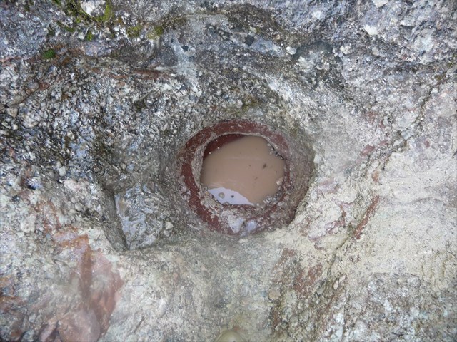
Gletschertöpfe sind topf- oder schachtartige Vertiefungen in Felsgestein (Kolke), die durch fließendes Wasser im Bereich von Gletschereis entstehen.

Entstehung
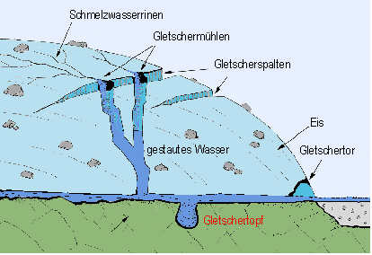
Gletschertöpfe bilden sich durch Schmelzwasser, das durch die Gletscherspalten und insbesondere Gletschermühlen** zum Gletscherbett hin abfließt. Dieses Schmelzwasser vereinigt sich zu Strömen und bildet an gewissen Stellen Wirbel. In diesen Wirbeln herrschen Fließgeschwindigkeiten von bis zu 200 km/h und hoher Druck. Die Haupterosionsarbeit mit Aushöhlen des Felsbettes leisten dabei der mitgeführte Sand und die Kiespartikel. Die Theorie, dass ein im Wasser drehender Findlingden Gletschertopf wie ein Mühlestein aus dem Felsen fräst, gilt als veraltet. Primär handelt es sich um den Auftreffpunkt einer Gletschermühle, oder lokale Wirbel im Basisstrom des subglazialen Wassers.
**Gletschermühlen sind spiralwandige Hohlformen im Eis, die von an der Gletscheroberfläche oder in Spalten abfließendem Schmelzwasser geschaffen worden sind. Das Schmelzwasser versetzt Gesteinstrümmer verschiedener Korngrößen in kreisförmige Bewegung. Sie erweitern und vertiefen die Gletschermühle und werden dabei selbst rundgeschliffen.
Gletschermühlen können Durchmesser von bis zu 20 Metern erreichen und entstehen meist in flachen Bereichen des Gletschers mit horizontalen Gletscherspalten. Sie können bis zum Grund des Gletschers reichen und hunderte Meter tief sein.
"Quelle Wikipedia"


Logbedingungen :
1. Ermittle den Durchmesser und die Tiefe des Gletschertopfes
2. Beschreibe das Gestein des Gletschertopfes bezüglich Struktur (Größe, Form, Farbe, Bestandteile) und Textur (räumliche Anordnung der Bestandteile und Schichtung)
3.Optional : hänge ein Foto von Dir oder deinem GPS am Gletschertopf an deinen Log
Sende uns die Antworten an high5tirol@hotmail.com
oder über unser Profil
Es kann sofort geloggt werden, falls die Angaben stark abweichen melden wir uns bei Dir.
Achtung: Bitte schaut euch die Spoiler Bilder gut an da die Koordinaten in diesem Gelände sehr ungenau sind!!!!
Bitte tragt gute Kleidung wenn ihr in die Klamm geht! Es gibt keinen Wanderweg zum Earth-Cache!!!!! Zu empfehlen sind Badehose und Wassersportschuhe!!!
Wichtig: Natürlich wird für Unfälle und Schäden aller Art keine Haftung übernommen!!!
Liebe Grüße an die gesamte Cachergemeinde :-)
High5tirol

[ EN ]
Glacial potholes are pot-or shaft-like depressions in rocks (Kolke) caused by flowing water in the area of glacial ice.

Formation
Glacial potholes are formed by melt water that flows through the crevasses and glacier mills** especially towards the glacier bed. This melt-water streams and unites to form at certain points vertebrae. These vortices dominate flow rates of up to 200 km / h high pressure. The main erosion work with hollowing out the rock bed make it the entrained sand and gravel particles. The theory that a rotating boulder in the water mills the pothole like a mill stone from the rock, is deprecated. Primarily it is the incidence of a glacier mill, or local vortices in the base current of the subglacial water.
**Glacier mills are spiral-walled cavities in the ice that have been created by glacial runoff at the surface or in the column melt water. The melt water displaced rock debris of various grain sizes in circular motion. Expand and deepen the glacier mill and ground it around itself.
Can crushers glacier diameter of up to 20 meters reach and usually develop in shallow areas of the glacier with crevasses horizontal. You can extend to the bottom of the glacier and its hundreds of meters deep.
"Quelle Wikipedia"


Log conditions:
1. Estimate the diameter and depth of the glacier pot
2. Describe the rock glaciers of the pot in terms of structure (size, shape, color, ingredients) and texture (spatial arrangement of the components and stratification)
3. Optional: hang a photo of you or your GPS at the pothole on your log
Send us the answers to high5tirol@hotmail.com
or on us profile
It can be logged immediately if the data deviate strongly do I register with you
Note: Please have a look at the spoiler pictures well as the coordinates are very inaccurate in this area!!
Please consider submitting good clothes when you go into the gorge! There is no trail to the Earth-Cache!! Are recommended swimwear and water sports shoes!
Important: Of course no liability for accidents or damages of any kind!
Best wishes to all Cacher´s :-)
High5tirol