These Waterfall Hikes Don’t Require a Timed Permit
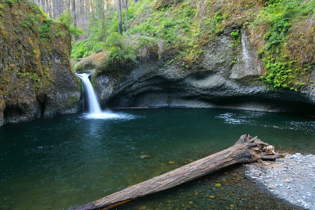
Punch Bowl Falls
Image: Courtesy Bill Kirkland
A good waterfall hike isn’t hard to come by if you live in Portland, what with the Columbia River Gorge practically at our doorstep. But with the new timed-use permits now required for driving to sites along the Gorge’s ever-so-scenic waterfall corridor and Multnomah Falls during summer, you’ll have to do some planning depending on where you want to go.
The new program from the US Forest Service and local and state agencies was put in place to ease traffic congestion along the area’s most visited attractions, and from May 24 through September 5, you need a permit to drive to trailheads for hiking spots between Interstate 84 exits 28 (Bridal Veil) and 35 (Ainsworth) between 9 a.m. and 6 p.m. This includes some of the area’s hottest haunts: Multnomah Falls, Horsetail Falls, and Wahkeena Falls. Permits aren’t hard to get, but if they’re all claimed or you don’t want to bother with one (or pay the “free” permit’s $2 reservation fee), there’s plenty to see beyond this well-worn corridor. Here are some waterfall trails you can go to for a leisurely summer stroll that don’t require a timed-use permit. (Note that some still require a parking permit or fee, but not the kind that is timed or limited in number.)
Eagle Creek to Punch Bowl Falls
- Distance: 4.2 miles
- Elevation gain: 525 feet
- Difficulty: Easy
- Type: Out and back
- Fee: Northwest Forest Pass required ($5 /day)
The last year or so has been tough for hikers longing to once again trek the Eagle Creek trail—the trail briefly reopened in January 2021 after a lengthy closure due to the 2017 fire, when more than 150 hikers had to be rescued and nearly 49,000 acres burned—only to close twice more (once again in 2022) due to landslides. But the trail is now officially open, in case you haven’t heard, and just so happens to have one of the best waterfalls and swimming holes in the gorge. The narrow trail skirts along a basalt canyon overlooking Eagle Creek, and if you’re bringing along children or dogs be prepared to carry them, as it’s a very steep drop. (Cable lines have been installed along the cliff edge to assist you.) Just the fact that this trail exists is a miracle itself: the construction project that launched in 1915 involved workers blasting the sides of cliff edges with dynamite to create a trail.
The out and back hike to Punch Bowl Falls is just a little over four miles, with a couple of other waterfalls to view from a distance along the way: the 100-foot Sorenson Falls, which is now visible due to many of the surrounding trees being consumed by the 2017 wildfire, and the 82-foot Metlako Falls. Soon enough you’ll come to the junction for the Lower Punch Bowl Trail and make a right, which drops you down by the creek—what was once an easy walk along the creek bed now requires scrambling over rocks (the result of a 2018 landslide) if you want to view Punch Bowl Falls from the creek. From here you can either turn back to the trailhead or continue on another four miles to Tunnel Falls (which you can walk behind).
Bonus tip: Eagle Creek tends to get very crowded in the summer, especially on weekends. So, unless you plan to get there super early (and preferably on a weekday) consider spending the night at Eagle Creek Campground (you can book at recreation.gov, and yes, there are still spots available to reserve this summer during the week) which is just a 15-minute walk from the trailhead, meaning you can get a very early start without the 6 a.m., barely caffeinated drive from Portland. There are also backpacking loops that connect to the trail with a number of campsites; however, those tend to fill up quickly in summer.
Dry Creek Falls
Image: Michelle Harris
Dry Creek Falls
- Distance: 4.4 miles
- Elevation gain: 725 feet
- Difficulty: Easy
- Type: Out and back
- Fee: Northwest Forest Pass required to park at Bridge of the Gods Trailhead ($5/day)
Despite its name, Dry Creek Falls flows all year long. Once used as a municipal water source for the town of Cascade Locks, the falls and creek did at one point run dry after being diverted into pipes. You can still see the ruins from the diversion system at the base of the falls. Surrounded by a basalt rock amphitheater, the 74-foot waterfall is the icing on the cake after a relatively easy ramble that begins at Bridge of the Gods Trailhead in Cascade Locks (also the bridge where Portland author Cheryl Strayed ends her journey in Wild). You’ll need a Northwest Forest Pass to park at Bridge of the Gods Trailhead, but other free options include PCT Harvey Road Trailhead or along Wa Na Pa Street in downtown Cascade Locks. After weaving through a pretty sun-speckled forest of Douglas fir and big-leaf maple along the Pacific Crest Trail, you’ll come to a footbridge that goes over Dry Creek. Rather than cross the footbridge, bear right and ascend the trail to Dry Creek Falls, where there are also plenty of spots to sit and take a rest before heading back.
Cape Horn
- Distance: 7.4 miles
- Elevation gain: 1,230 feet
- Difficulty: Moderate
- Type: Loop (from July 16 to January 31)
- Fee: None
The entire 600-foot Cape Horn Falls can be viewed only while aboard a boat on the Columbia River or from across the river at Bridal Veil Falls. Nonetheless, from July 16 through January 31, you have the option to hike the loop trail, which crosses a bridge just below the middle tier of the falls. The lower end of the trail that skirts along the cliffs of Cape Horn is closed off the rest of the year in order to protect nesting peregrine falcons. The trail is over seven miles long, and you’ll want to give yourself extra time for photo breaks and (and snacks) at the scenic viewpoints along the way. Right before you reach Cape Horn Falls, you’ll pass a view of Cigar Rock—a basalt rock rising over the river that resembles a cigar—before traversing a series of switchbacks along mossy talus slopes. This section can be rocky, so proceed with caution. You’ll then come to a bridge that crosses right in front of the falls. It should be mentioned that there’s a chance Cape Horn Falls will dry out by the end of summer, but even if you catch the falls when it’s more like a shower sprinkle than a gushing waterfall, it’s still a great way to cool off. To complete the loop, you’ll descend along switchbacks on a woodsy trail before it opens up to Cape Horn Road. Take in bucolic scenery of cows and goats before on the way to the pedestrian underpass below WA 14 and back to the trailhead.
Falls Creek Falls
- Distance: 3.4 miles
- Elevation gain: 850 feet
- Difficulty: Easy
- Type: Out and back
- Fee: None
Tucked away in Washington’s Gifford Pinchot National Forest, the 335-foot, multitiered Falls Creek Falls is arguably one of the most striking waterfalls in the area, and is well worth the 90-minute drive. Be prepared to chug along a forest road for over two miles before reaching the trailhead. The trail meanders along Falls Creek beneath a canopy of Douglas fir, big-leaf maple and alder. There are also various access spots along the creek for a quick snack break. Almost half a mile in from the trailhead you’ll reach a suspension bridge that takes you over a narrow gorge. You’ll then continue uphill and pass a junction with a connector trail (which you won’t take) and follow the Falls Creek Falls trail to the base of the falls, where the lowest section of the waterfall drops 90 feet over a rocky amphitheater—from this viewpoint you also get a glimpse of the middle tier gently cascading over the cliff face. Up for a longer hike? Return to the junction and take the connector trail up a steep hill, which will take you to a viewpoint of the upper falls. From here return to the main trail to finish the hike.


