Recently Viewed ›
Recently Downloaded 
Close x

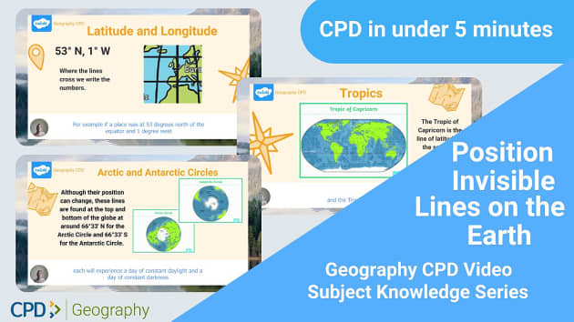
Use this quick, easy-access CPD video to support your KS2 pupils with developing their locational knowledge. This video will ensure you have the subject knowledge necessary to teach about the invisible lines on the Earth and explore the vocabulary needed for this unit.
This helpful video addresses a key point in the primary education national curriculum for geography as a part of their locational knowledge learning. Students need to be able to 'identify the position and significance of latitude, longitude, Equator, Northern Hemisphere, Southern Hemisphere, the Tropics of Cancer and Capricorn, Arctic and Antarctic Circle, the Prime/Greenwich Meridian and time zones (including day and night).'
If you haven't already, be sure to check out the other videos in this CPD series. The first one, Video 1 Locational Knowledge CPD: Locating and Remembering, provides support for teaching pupils how to find countries and cities in different parts of the world. The second in the series, Video 2 Locational Knowledge CPD: Locational Knowledge, covers human, physical, and topographic features.
 equator
geography grade 6 term 1
longitude latitude
geography
social science posters
longitude and latitude
mapungubwe posters
grade 5 geography term 1
longitude and latitude geography worksheet
year 5 geography
grade 6 geography term 1
latitude and longitude worksheet
latitude
longitude and latitude geography
equator
geography grade 6 term 1
longitude latitude
geography
social science posters
longitude and latitude
mapungubwe posters
grade 5 geography term 1
longitude and latitude geography worksheet
year 5 geography
grade 6 geography term 1
latitude and longitude worksheet
latitude
longitude and latitude geography
This resource is not yet rated. Why not leave your own review?
Use this quick, easy-access CPD video to support your KS2 pupils with developing their locational knowledge. This video will ensure you have the subject knowledge necessary to teach about the invisible lines on the Earth and explore the vocabulary needed for this unit.
This helpful video addresses a key point in the primary education national curriculum for geography as a part of their locational knowledge learning. Students need to be able to 'identify the position and significance of latitude, longitude, Equator, Northern Hemisphere, Southern Hemisphere, the Tropics of Cancer and Capricorn, Arctic and Antarctic Circle, the Prime/Greenwich Meridian and time zones (including day and night).'
If you haven't already, be sure to check out the other videos in this CPD series. The first one, Video 1 Locational Knowledge CPD: Locating and Remembering, provides support for teaching pupils how to find countries and cities in different parts of the world. The second in the series, Video 2 Locational Knowledge CPD: Locational Knowledge, covers human, physical, and topographic features.
For more help improving your knowledge of longitude and latitude, we’ve created a super handy fact sheet you can refer to when teaching or planning geography lessons. This Adult Subject Knowledge Sheet Invisible Lines on the Earth sheet has an informative list of the different invisible lines on the Earth and their definitions. It's important that your KS2 know how to identify these invisible lines and their significance.
This Lines of Latitude and Longitude Teaching Pack is perfect to use in a lesson about invisible lines on the Earth. It comes with two fantastic PowerPoints on longitude, latitude and timezones. These are packed with important keywords and information to help your students develop their geography skills!
Looking for more expert teaching support? We’ve got you sorted. Check out our whole section on KS2 Geography CPD. Designed to help you teach your students in line with the national curriculum. Our CDP resources cover fieldwork, subject knowledge, teaching resources and (coming soon!) support for subject leaders.
The Equator - An imaginary line around the middle of the Earth, equidistant from the North and South Poles.
Northern and Southern Hemisphere - The two halves or hemispheres of the Earth on either side of the equator.
Latitude - These lines run horizontally to the equator and are used with longitude to mark exact locations.
Longitude - These lines run vertically to the equator, measuring distances east and west of the Greenwich Meridian.
The Prime / Greenwich Meridian - This is a central line vertical to the equator, creating a circumference that goes through London. This is used to help plot east and west.
The Tropic of Cancer and the Tropic of Capricorn - These are the most northerly and southerly lines of latitude. The Tropic of Cancer is at the northern edge, and the Tropic of Capricorn is at the southern.
Arctic and Antarctic Circle - These lines are at the very top and bottom of the Earth.
 Home
Home  Membership
  Customer Support
  Create
  Blog
Blog