
Public Storm Warning Signals are raised to warn the public of incoming disturbances. Once a storm signal is raised, conditions are not yet necessarily felt in a certain area.
An area’s given signal number is based on the intensity, size of circulation and the forecast direction, and speed of the tropical typhoon when the Public Storm Warning Signal is raised.
PUBLIC STORM WARNING SIGNAL #1
Tropical cyclone will affect the locality. Winds of 30-60kph will be expected in at least 36 hours.
Impact of the Winds:
- Twigs and branches of small trees may be broken.
- Some banana plant will be tilted or downed.
- Some houses made of light materials may be partially unroofed. Unless this signal is upgraded during the entire existence of the tropical cyclone, only very light or no damage at all may be sustained by the exposed communities.
Precautionary Measures:
- When the tropical cyclone is strong and is moving closer, this signal may be upgraded to the next higher level.
- The waves on coastal waters may gradually develop and become bigger and higher.
- Disaster preparedness is activated to alert status.
PUBLIC STORM WARNING SIGNAL #2
A tropical cyclone will affect the locality. Winds of greater than 60kph and up to 100kph may be expected in at least 24 hours.
Impact of the Winds:
- Some coconut trees may be tilted with few others broken.
- Few big trees may be uprooted.
- Many banana plants may be downed.
- Rice and corn may be adversely affected.
- Large number of nipa and cogon houses may be partially or totally unroofed.
- Some old galvanized iron roofings may be peeled off.
- In general, the winds may bring light to moderate damage to exposed communities.
Precautionary Measures:
- The sea and coastal waters are dangerous to small sea-crafts.
- Special attention should be given to the latest position, the direction and speed of movement and the intensity of the storm as it may intensify and move towards the locality.
- The general public especially people traveling by sea and air are cautioned to avoid unnecessary risks.
- Outdoor activities of children should be postponed.
- Secure properties before signal is upgraded.
- Disaster preparedness organizations are in action to alert their communities.
PUBLIC STORM WARNING SIGNAL #3
A tropical cyclone will affect the locality. Winds of greater than 100kph up to 185kph may be expected in at least 18 hours.
Impact of the Winds:
- Many coconut trees may be broken or destroyed.
- Almost all banana plants may be downed and a large number of trees may be uprooted.
- Rice and corn crops may suffer heavy losses.
- Majority of nipa and cogon houses may be unroofed or destroyed and there may be considerable damage to structure of light to medium construction.
- There may be widespread disruption of electrical power and communication services.
- In general, moderate to heavy damage may be experienced, particularly in the agricultural and industrial sectors.
Precautionary Measures:
- The disturbance is dangerous to the communities threatened.
- The sea and coastal waters will be very dangerous to all sea crafts.
- Travel is very risky especially by sea and air.
- People are advised to seek shelter in strong buildings, evacuate low-lying areas and to stay away from the coasts and river banks.
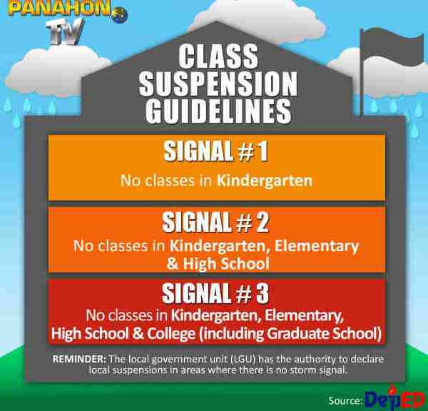
- Classes in all levels should be suspended and children should stay in the safety of strong buildings.
- Disaster preparedness and and response organizations are in action with appropriate response to actual emergency.
PUBLIC STORM WARNING SIGNAL #4
A very intense typhoon will affect the locality. Very strong winds of more than 185kph may be expected in at least 12 hours.
Impact of the Winds:
- Coconut plantation may suffer extensive damage.
- Many large trees may be uprooted.
- Rice and corn plantation may suffer severe losses.
- Most residential and institutional buildings of mixed construction may be severely damaged.
- Electrical power distribution and communication services may be severely disrupted.
- In the overall, damage to affected communities can be very heavy.
Precautionary Measures:
- The situation is potentially very destructive to the community.
- All travels and outdoor activities should be cancelled.
- Evacuation to safer shelters should have been completed since it may be too late under this situation.
- With Public Storm Warning Signal #4, the locality is very likely to be hit directly by the eye of the typhoon. As the eye of the typhoon approaches, the weather will continuously worsen with the winds increasing to its strongest coming generally from the north. Then a sudden improvement of the weather with light winds will be experienced. This means that the eye of the typhoon is over the locality. This improved weather may last for one to two hours depending on the diameter of the eye and the speed of movement. As the eye moves out of the locality, the worst weather experienced before the lull will suddenly commence. This time the very strong winds will come generally from the south. The disaster coordinating councils concerned and other disaster response organizations are now fully responding to emergencies and in full readiness to immediately respond to possible calamity.
