File:Klimazonen- Unklare Subpolare Zone.png
Jump to navigation
Jump to search

Size of this preview: 800 × 434 pixels. Other resolutions: 320 × 174 pixels | 640 × 347 pixels | 1,024 × 556 pixels | 1,280 × 695 pixels | 2,560 × 1,390 pixels | 4,779 × 2,594 pixels.
Original file (4,779 × 2,594 pixels, file size: 2.25 MB, MIME type: image/png)
Captions
Captions
Add a one-line explanation of what this file represents
Summary[edit]
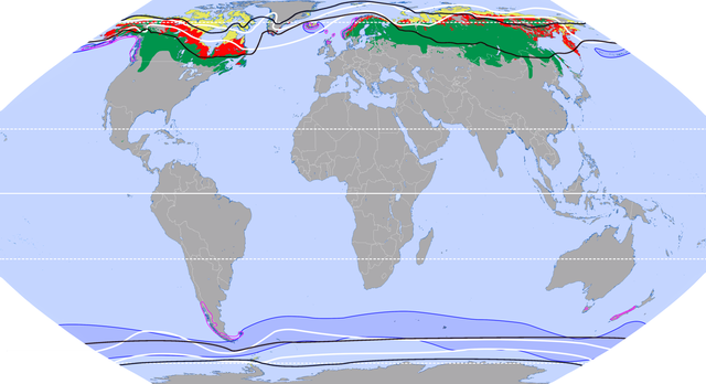
Legende[edit]
Subpolare Zonengrenzen:
Schwarz = nach Lauer, Rafiqpoor und Frankenberg
Weiß = nach Neef (Flohn)
Vegetation u./o. Klimate:
Tundra
Waldtundra
Borealer Nadelwald
⛯ Cfc-Klima nach Köppen
⛯ I4-Klima nach Troll
Summary[edit]
| Description |
Deutsch: Subpolare Klimazonen. Grenzen nach zwei bekannten Klimaklassifikationen (Rafiqpoor & Frankenberg / Neef (nach Flohn). Farbflächen: Elementare Makroklimate / Vegetationszonen, die – in unterschiedlicher Weise – mit den subpolaren Zonen gleichgesetzt werden. English: Sub-polar climate zones. Boundaries according to two well-known climate classifications (Rafiqpoor & Frankenberg / Neef (according to Flohn). Color areas: elementary macroclimates / vegetation zones, which – in different ways – are equated with the sub-polar zones. |
| Date | |
| Source |
Own work QuellenKartographie:
Datengrundlagen:
|
| Author | Fährtenleser |
Licensing[edit]
I, the copyright holder of this work, hereby publish it under the following license:
This file is licensed under the Creative Commons Attribution-Share Alike 3.0 Unported license.
- You are free:
- to share – to copy, distribute and transmit the work
- to remix – to adapt the work
- Under the following conditions:
- attribution – You must give appropriate credit, provide a link to the license, and indicate if changes were made. You may do so in any reasonable manner, but not in any way that suggests the licensor endorses you or your use.
- share alike – If you remix, transform, or build upon the material, you must distribute your contributions under the same or compatible license as the original.
File history
Click on a date/time to view the file as it appeared at that time.
| Date/Time | Thumbnail | Dimensions | User | Comment | |
|---|---|---|---|---|---|
| current | 10:39, 1 April 2023 | | 4,779 × 2,594 (2.25 MB) | Fährtenleser (talk | contribs) | Korrektur Köppenklima Cfc u. Ergänzung Troll-Klima I4 |
| 18:32, 6 January 2023 |  | 4,779 × 2,594 (8.68 MB) | Fährtenleser (talk | contribs) | Cfc war leider viel zu groß geraten ... Nun nach besserer Grundkarte | |
| 17:52, 9 December 2022 |  | 4,779 × 2,594 (8.14 MB) | Fährtenleser (talk | contribs) | Südküste Island Cfc-Klima korrigiert | |
| 14:45, 13 November 2022 |  | 4,779 × 2,594 (6.91 MB) | Fährtenleser (talk | contribs) | Ozeanisches Subpolarklima (Klima der gemäßigten Regenwälder) ergänzt | |
| 08:19, 10 November 2022 |  | 4,779 × 2,594 (5.26 MB) | Fährtenleser (talk | contribs) | Breitenkreise beschriftet | |
| 18:07, 10 October 2022 |  | 4,779 × 2,594 (2.07 MB) | Fährtenleser (talk | contribs) | == Legende == '''Subpolare Zonengrenzen:''' <span style="color:#000000">'''<big><big><big><big>—</big></big></big></big>'''</span> nach Lauer, Rafiqpoor und Frankenberg <span style="color:#ffffff">'''<big><big><big><big>—</big></big></big></big>'''</span> nach Neef (Flohn) '''Vegetation u./o. Makroklimate:''' {{legend|#e7e75e|Tundra}} {{legend|#ff0505|Waldtundra}} {{legend|#00944c|Borealer Nadelwald}} =={{int:filedesc}}== {{Information |description={{de|1=Subpolare Kli... |
You cannot overwrite this file.
File usage on Commons
There are no pages that use this file.
File usage on other wikis
The following other wikis use this file:
- Usage on de.wikipedia.org
- Usage on lt.wikipedia.org